News – Sheridan Media

Not far from Sheridan, carved on a huge sandstone cliff, is the name Wm Clark, and the date, July 25, 1806. Captain William Clark was one of the leaders of the Lewis and Clark Corps of Discovery Expedition.
In 1803, President Jefferson purchased a vast territory, 828,000 square miles, from France for only $15,000,000. This territory comprised what is now the states of Louisiana, Missouri. Arkansas, Iowa, Minnesota, North Dakota, South Dakota, Nebraska, Oklahoma and the largest parts of Kansas, Colorado, Wyoming and Montana.

In 1804-1806 Captain Meriwether Lewis and Captain William Clark undertook a scientific expedition across the continent to explore the new lands. This trip resulted in a wonderful enrichment of the government’s scientific knowledge of the country, the animals and the Native American’s they encountered along the way.
When visiting a Mandan Villiage, the explorers hired a French trapper who brought his young wife, Sacajawea, along. While with the expedition, Sacajawea gave birth to a son, which Captain William Clark nicknamed Pompey or Little Pomp.

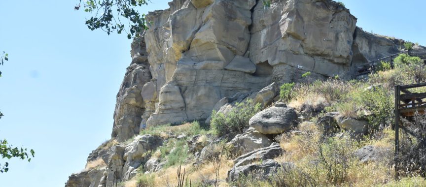
The Lewis and Clark expedition traveled from St. Louis, Missouri to the Pacific Coast. On his return trip, on July 25, 1806, Captain William Clark stopped by a huge sandstone cliff overlooking the Yellowstone River, located not far from the present town of Billings, Mt. He named the cliff, Pompey’s Pillar, or Pompey’s Tower, and carved his name, as well as the day of the month and the year.
When Pompey grew older, Clark provided him an education at the St. Louis Academy. Pompey’s real name was Jean Baptise Charboneau. His father was also member of the Lewis and Clark expedition, a trader named Toussaint Charbonneau. For years afterwards, Jean Baptiste was a trapper and a guide in the Rocky Mountain Region.
This from The Powell Tribune, September 15, 1916 – This is part of a much longer story about Sacajawea, that mentionsJean Baptise. When she became old and feeble Sacajawea returned to her own people, the Shoshones, who were in the habit of roving from Idaho to Wyoming. In the neighborhood of Bridger’s fort, in the ’30’e and ’40’s, young Charboneau. Sacajawea’s son was a well known guide to Wyeth, Bonneville, Fremont and others and is mentioned in several overland journals of that period. Captain William Clark Kennerly of St. Louis, a nephew of Captain Clark of the expedition told Mrs. Dye when she was writing “The Conquest.” that he and Jefferson K. Clark out on a hunting trip, met Sacajawea’s son at Bridger’s Fort in 1842 and knew he was the identical boy educated by Governor Clark in St. Louis.

View from the Top
The Sheridan Post, February 25, 1910, about an irrigation project near Pompey’s Pillar, with a description of the huge rock, and Captain William Clark’s signature. – Pompey’s Pillar Huntley Project Opening of Sale of Lots in the New Town. Some Of the Things That Have Been Accomplished on This Reclamation Project In the Past Two Years. The opening for sale of town lots in the town of Pompey’s Pillar, on the Huntley irrigation project, Montana, beginning April 7, marks an epoch in the evolution of the Yellowstone valley. Pompey’s Pillar is one of the best identified and known of the features described by Lewis and Clark in their famous transcontinental expedition. Captain William Clark etched his name on one side of the pillar, and it has been preserved during the century that has elapsed since these two brave explorers discovered the country and described it.

The pillar is of sandstone formation and has a diameter of about two hundred feet and a height of approximately 75 feet. In order to preserve the name of Captain Clark, an iron grating has been placed across the face of the cliff at the point where the name appears, and has been anchored into the solid rock, which will preserve for years the handiwork of this remarkable man.

In 1956, to further protect the inscription from weather and vandalism, the iron grating was replaced with bullet and shatter-proof glass, edged in bronze. In this way, his handiwork can be seen by future generations.
Pompey’s Pillar was a well-known landmark for many years, as we see in this story in the Cheyenne Weekly Leader, June 24, 1876.
From Daily Leader, June 20 – Latest from Gen. Gibbons Command – S. D. Lutes, who accompanied Gen. Gibbons’ Big Horn expedition and returned with the wagon train, states that on the 1st of June the command camped about thirty miles north of Tongue River awaiting the advance of Terry and Crook. No Indians, except in small squads, had been seen. The men were living on half rations, and the horses were getting poor. The supply train recently sent down has probably reached the command. It was met near Pompey’s Pillar on the 29th of May. Col. Chestnut’s boat was met within two hours run of the command. Ho was the bearer of dispatches to Gen. Gibbon, the boat being loaded with vegetables, etc. In passing Fort Pease, Mr. Lutes says, it was on fire, a great portion of it being burnt. Fresh Indian tracks were seen around it.
On the 23rd of May, privates Stoker and H Rahmier, of Co. H, 2nd cavalry, and James Quinn, a citizen employed as teamster, were out hunting, and when about two miles from the command, they came upon a party of Indians in ambush, and were all instantly killed. The Indians allowed them to approach so close to where they were concealed that Quinn’s breast was burnt by the powder of the Indian’s guns. It would appear from this that the Indians are closely watching every movement of Gen. Gibbon’s command, and will pick off every man who ventures outside of the picket lines.[Bozeman (M. T.) Avant Courier.

William Clark was born on August 1, 1770, and this from The Wyoming Press, April 1, 1905 – August 1 has been decided upon as Kentucky day at the Lewis and Clark Expedition. August 1 was the birthday of Captain William Clark, who shared with Captain Lewis the dangers and privations of the Lewis and Clark expedition. Captain Clark was for twenty years a resident of Kentucky.
Today, Pompey’s Pillar is a National Monument and Historic Site about 30 miles from Billings, Montana. William Clark’s name on the rock is the only remaining on-site physical evidence of the Lewis and Clark Expedition. To preserve it from weather and vandalism, the signature is protected by a clear bullet and shatter-proof glass set in edged in bronze.

There is a walking path with a boardwalk and stairs up to the top of the rock, where one can see basically the same view that Clark would have seen. There is Interpretive Center at the base of the cliff, that has exhibits, maps and information about Lewis and Clark’s journeys.
All photos taken at Pompey’s Pillar National Monument and Historic Site and Interpretive Center. (Vannoy Photos)

More Like this
 Wyoming Man Arraigned in Federal Court for Distribution of Child Pornography
 County Courthouse and Sheridan County libraries will close at 1 p.m. due to severe weather
 Flood Watch Issued For Sheridan County And Big Horn Mountains – Monday, April 28, 2025
Last modified: July 27, 2025